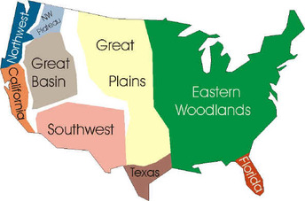
This map is of where each Native American groups are located throughout the United States of America.As the map shows the Eastern Woodlands Native Americans lived in the Eastern United States.Woodland Indian tribes lived east of the Plains Indians and extended from New England and Maryland to the Great Lakes Area and into Maine. They lived in the forests near lakes or streams, which is why they're called Eastern Woodland Indians.http://www.kidzworld.com/article/1330-american-indians-woodland-tribes-and-california-indians
http://www.fourdir.com/chapter_3_native_american_cultures.htm
They had some waterways that connected to the St. Lawrence River, The Great Lakes, and the Atlantic Coast.
